

Driving Directions
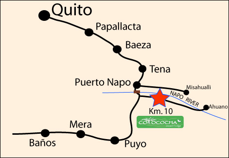
Route description Quito - Cotococha Amazon Lodge
There are two possibilities to leave Quito and get to the valley of Cumbaya. This description has been made departing from the Mariscal district:
Part 1: Departing Quito
1) Take the Av. 6 de Diciembre in northern direction, passing the Colon Avenue and Republica Avenue. You will get to a small park (Plaza Argentina), where there are several side roads to the left, keep driving on the Av. 6 de Diciembre (keeping the Ecovia at your left hand side). You will pass a couple of traffic lights and get to the intersection with the Av. Eloy Alfaro. Turn right on the Eloy Alfaro and continue this road passing the offices of Equinoccial Insurances, the Church La Fatima, Parque Chile, several flower kiosks & a Land Rover dealer. The next traffic light where the Land Rover dealership is turn right (you will be turning on the Av. Granados - if you pass this you will have a Supermaxi on the right and a cemetery on your left). At the next roundabout keep going straight - you are now leaving Quito. Continue on this road until you reach a bridge; make a right turn, following the sign Cumbaya (can either be just before or just after passing underneath the bridge). You'll get on top of the bridge; follow the road descending towards the village centre of Cumbaya.
2) Take the Av. 12 de Octubre in northern direction. Cross the Swissotel at the corner with Cordero Street and get to a roundabout. Keep going straight on (1/2 roundabout) and stick to the Av. 12 de Octubre, you'll reach another roundabout almost immediately. Go straight on (1/2 round about), the Av. 12 de Octubre becomes the Av. Gonzalez Suarez at this point. Pass the hotel Quito at your right hand side and right after this hotel turn right following the sign Universidad SEK. You'll be driving downhill now, at the first intersection take a left turn (almost U-turn) and the road will become cobble-stoned. Follow the zigzag curves descending to the church of Guapulo. Take a right turn at the church, after a couple of meters you'll reach a traffic light. Take a left turn here and continue the road with some serious curves, until you get to a small bridge and a T-crossing. Take a right turn crossing another (larger) bridge. Drive uphill and you'll reach another T-crossing where you have to take a left turn continuing on the cobble-stoned road. After approximately 5 to 10 minutes you'll reach the village centre of Cumbaya.
Part 2: From Cumbaya to Tena
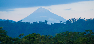
Passing the modern shopping centre of Cumbaya, you'll get to a big roundabout, keep to your right (1/4 round about). Pass underneath a small bridge and you get to another roundabout where you have to go straight on (1/2 round about). Pass 2 traffic lights (difficult to spot!), here is also the new Hospital de los Valles. This road will lead to Tumbaco, pass the big supermaket 'Supermaxi' and the shopping Mall 'Via Ventura' at your right hand. Pass several traffic lights and the village of Tumbaco. Continue on the road and pass the bridge crossing a deep gorge before getting to the intersection with the side road to Puembo. Keep on the new road towards Pifo. The road will become smaller and right after Pifo you have the possibility to take a left turn towards El Quinche, stick to the main road and go straight on passing a few petrol stations. Continue on this road until you get to another intersection with the 'interval's highway' keep to your left. From here on there are no more side roads. You'll climb to the mountain pass and after 30 minutes cross the highest point of 4065mts. From here it's mainly downhill. Within 15 minutes you'll see a big lake at your left hand side (Laguna Papallacta) and at the very end of this lake the road gets unpaved for a couple of kilometres. Pass Papallacta and the road will get paved again. Continue driving for another hour and you'll reach the military control of Guagrayacu. Pass this control unit and keep to your right following the sign Baeza. After 10 minutes you'll get to the town of Baeza. Pass this town and continue driving to the town of Cosanga. Here is where the bad road condition starts. Cross the bridge of Cosanga and you'll start de ascent of the Guacamayos mountain range. Here you will have the first spectacular sights of the Amazon basin. Pass the village of Sarayacu where you'll have a couple of kilometres of paved road. Continue on the same road until you reach an intersection with the road to Coca. Keep to your right and continue following the sign Archidona - Tena. From here it's not too far anymore to Archidona. At Archidona you can cross the village or take the road to the right, keeping the first petrol station on your left hand side. You'll pass another petrol station and then a bridge. From here it's another 30 minutes of unpaved road to Tena.
Part 3: From Tena to Cotococha Amazon Lodge
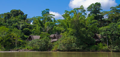
At Tena cross the bridge over the River Tena and continue this road until you leave the town. You'll pass the university Politecnica (a big, modern building with green windows) at your left hand side and you'll reach the small village of Puerto Napo. Cross the bridge over the river Napo and directly after this bridge turn left. This is the road Pto. Napo – Ahuano – Santa Rosa. Continue for 10 km (approx. 20 minutes) on this road and you'll see the sign of Cotococha at your left hand side. Continue until you reach the big, thatched, sign with the car park. Welcome to Cotococha!


